


Purchase History
| Date | Event | Price | Source | Agents |
|---|---|---|---|---|
| 11/22/2005 | Sold | $532,500 | Public records |
Cost estimate history
| Year | Tax | Assessment | Market |
|---|---|---|---|
| 2014 | $8,579 | $485,000 | N/A |
Market Activities
Building Permits
To date, we have no information about building permits in 2025
Nov 4, 2002
Description: Log in cross street: lone quail roaddescription of work: master plan for map 14396 (tm5256r), lots 71-86, phase 5, 16 production units for "tanglewood" single family section of subdivision. see 1015-20021182 for all clearancesplan 1 -- lot 711310 sq ft sfd/ac/fs454 sq ft attached garage (f)11 sq ft patio cover (hra)no options
- Parcel #: 678-502-08-01
- Permit #: PDS2002-1015-20021182
Fieldthorn St Fire Incident History
To date, we have no information about fire incidents in 2025
04 Mar 2010
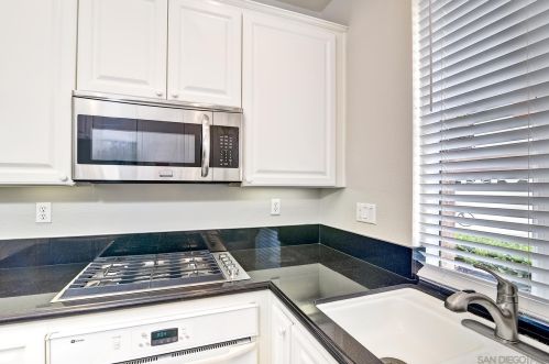
Fire, other
Property Use —
1 or 2 family dwelling
Area of Origin —
Cooking area, kitchen
First Ignition —
Electrical wire, cable insulation
Heat Source —
Heat from powered equipment, other
17 Apr 2005
Building fires
Property Use —
1 or 2 family dwelling
Area of Origin —
Attic: vacant, crawl space above top story, cupola
First Ignition —
Electrical wire, cable insulation
Heat Source —
Arcing
9945 Fieldthorn St incidents registered in FEMA
(Federal Emergency Management Agency)
To date, we have no information about incidents registered in FEMA in 2025
11 Dec 2010
Electrical wiring/equipment problem, other
Property Use —
1 or 2 family dwelling
Fieldthorn St Incidents registered in FEMA
(Federal Emergency Management Agency)
To date, we have no information about incidents registered in FEMA in 2025
11 Dec 2010
Electrical wiring/equipment problem, other
Property Use —
1 or 2 family dwelling
05 Sep 2008
Gas leak (natural gas or LPG)
Property Use —
1 or 2 family dwelling
06 Apr 2006
Gasoline or other flammable liquid spill
Property Use —
1 or 2 family dwelling
Properties Nearby
| Street Address | Residens/Landlords |
|---|