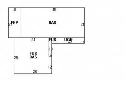
30 Maynard St Newton, MA 02465 / 1354

Residence for Single Family

(UPDATED: 07/06/2025)
  • 4 Beds
  • 3 Baths
  • 2.479 square feet
Property Report

Information about property on 30 Maynard St, Newton MA, 02465-1354. Find out owner contacts, building history, price, neighborhood at Homemetry Address Directory.

Property Details

This property with 2,479 square feet of effective area on 0,2 acres was put up in 1953.

Facts

  • Built in 1953
  • Property use Single Family
  • Lot size 8,590 sqft
  • Effective area 2,479 sqft
  • Building type Residential
  • Rooms 8
  • Bedrooms 4
  • Bathrooms 3
  • Stories 2
  • Exterior condition Average
  • Trim Half Wall
  • Foundation type Slab
  • Roof material Asphalt Shingl
  • Fuel type Oil
  • Air conditioning Central
  • Fireplaces 1
  • Frontage 78 feet
  • Shed area 48 sqft
  • Porch area 92 sqft
  • Enclosed porch area 168 sqft
  • Heating & Cooling
  • Heat type Hot Water
  • Exterior Home Features
  • Exterior walls Vinyl Siding
  • Roof type Gable

Features

  • Kitchen quality: Above Average

Householders and Tenants for 30 Maynard St, Newton MA

Possible residents contact details

Person Name Phone Number Additional Info
Ahmad Maksoud Age: 38
617-527-****
Hamdy A Abdel-Maksoud Age: 78
617-527-****
Hamdy A Maksoud Age: 78
617-527-****
Hamdy Abdel
617-527-****
Jian Li
Jing C Chan
MORTGAGE ELECTRONIC REGISTRATION SYSTEMS INC
Maksoud H Abdel
617-527-****
Martin S Karas
Mona H Maksoud Age: 68
617-527-****
Omar Maksoud Age: 40
617-527-****
Sandra Karas
Sen Zhang
WELLS FARGO BANK
30 Maynard St, Newton MA  02465-1354 plot plan 30 Maynard St, Newton MA  02465-1354 floor plan 30 Maynard St, Newton MA  02465-1354 aerial view

Purchase History

DateEventPriceSourceAgents
05/04/2010 Sold $549,200 Public records
02/02/2006 Sold $525,000 Public records

Cost estimate history

YearAssessment
2016 $689,100
2015 $644,000
2014 $613,800
2013 $521,300
2012 $521,300
2011 $522,900
2010 $615,900
2009 $628,500
2008 $628,500
2007 $566,500
2006$596,600
2005$568,200
2004$526,500
2003$470,100
2002$470,100
2001$392,800
2000$358,700
1999$326,400
1998$303,400
1997$286,200
1996$272,600
1995$259,200
1994$246,900
1993$246,900
1992$257,700

Where is 30 Maynard St, Newton MA located on map?

Maynard St Incidents registered in FEMA
(Federal Emergency Management Agency)

To date, we have no information about incidents registered in FEMA in 2025
08 Mar 2005 Electrical wiring/equipment problem, other
Property Use —
1 or 2 family dwelling

Properties Nearby

Street AddressResidens/Landlords
10 Maynard St, Newton, MA 02465-1316
Single Family
  • 4 beds
  • 1 bath
  • 6,309 sqft
  • Built in 2013
Gregory D Brown, Dolrudee Jumlongras
11 Maynard St, Newton, MA 02465-1315
Single Family
  • 3 beds
  • 1 bath
  • 1,974 sqft
  • Built in 1953
FRANKS FAMILY TRUST, Cynthia A Franks
16 Maynard St, Newton, MA 02465-1316
Single Family
  • 3 beds
  • 2 baths
  • 2,107 sqft
  • Built in 1953
Melinda E Mcgee, Philip C Notick
19 Maynard St, Newton, MA 02465-1315
Single Family
  • 3 beds
  • 1 bath
  • 1,750 sqft
  • Built in 1953
LI KEVIN YEUNG KWAN, LI NATHAN YEUNG YEE
24 Maynard St, Newton, MA 02465-1354
Single Family
  • 3 beds
  • 2 baths
  • 1,750 sqft
  • Built in 1953
Louis Green, Selma A Green
 

FAQ about the house at 30 Maynard St, Newton, MA


NOTICE: You may not use SpamRoom or the information it provides to make decisions about employment, credit, housing or any other purpose that would require Fair Credit Reporting Act (FCRA) compliance. SpamRoom is not a Consumer Reporting Agency (CRA) as defined by the FCRA and does not provide consumer reports.