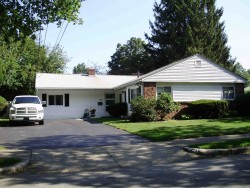
11 Maynard St, Newton MA  02465-1315 exterior

11 Maynard St Newton, MA 02465 / 1315

Residence for Single Family

(UPDATED: 08/18/2025)
  • 3 Beds
  • 1 Baths
  • 1.974 square feet
Property Report

Information about property on 11 Maynard St, Newton MA, 02465-1315. Find out owner contacts, building history, price, neighborhood at Homemetry Address Directory.

Property Details

This property has more than nineteen hundred square feet of effective area and sits on 0,18 acres.

Facts

  • Built in 1953
  • Property use Single Family
  • Lot size 7,800 sqft
  • Effective area 1,974 sqft
  • Building type Residential
  • Rooms 7
  • Bedrooms 3
  • Exterior condition Average
  • Trim Half Wall
  • Foundation type Slab
  • Roof material Asphalt Shingl
  • Fuel type Oil
  • Air conditioning Central
  • Frontage 80 feet
  • Shed area 70 sqft
  • Enclosed porch area 168 sqft
  • Deck area 224 sqft
  • Attached garage area 294 sqft
  • Heating & Cooling
  • Heat type Hot Water
  • Exterior Home Features
  • Exterior walls Vinyl Siding
  • Roof type Gable

Features

  • Bath quality: Above Average

Householders and Tenants for 11 Maynard St, Newton MA

Possible residents contact details

Person Name Phone Number Additional Info
Charles J Franks Age: 92
617-965-****
Residential status:
Homeowner
Christine M Franks Age: 62
617-965-****
Cindy Franks
617-965-****
Cynthia A Franks Age: 91
617-965-****
FRANKS FAMILY TRUST
Florida M Grant
GRUNES MARGERY A /S EXOR
GRUNES SAMPSON EXOR
Isabella C Hart
James E Grant
Margery A Grunes
Sampson Grunes
William E Hart
11 Maynard St, Newton MA  02465-1315 plot plan 11 Maynard St, Newton MA  02465-1315 floor plan 11 Maynard St, Newton MA  02465-1315 aerial view

Purchase History

DateEventPriceSourceAgents
10/02/1995 Sold $205,000 Public records

Cost estimate history

YearAssessment
2016 $490,700
2015 $458,600
2014 $433,200
2013 $433,200
2012 $433,200
2011 $431,800
2010 $440,600
2009 $449,600
2008 $449,600
2007 $452,000
2006$438,800
2005$408,900
2004$372,000
2003$332,100
2002$332,100
2001$287,300
2000$262,400
1999$238,800
1998$217,700
1997$205,400
1996$195,600
1995$174,600
1994$174,600
1993$174,600
1992$187,600

Where is 11 Maynard St, Newton MA located on map?

Maynard St Incidents registered in FEMA
(Federal Emergency Management Agency)

To date, we have no information about incidents registered in FEMA in 2025
08 Mar 2005 Electrical wiring/equipment problem, other
Property Use —
1 or 2 family dwelling

Properties Nearby

Street AddressResidens/Landlords
10 Maynard St, Newton, MA 02465-1316
Single Family
  • 4 beds
  • 1 bath
  • 6,309 sqft
  • Built in 2013
Gregory D Brown, Dolrudee Jumlongras
16 Maynard St, Newton, MA 02465-1316
Single Family
  • 3 beds
  • 2 baths
  • 2,107 sqft
  • Built in 1953
Melinda E Mcgee, Philip C Notick
19 Maynard St, Newton, MA 02465-1315
Single Family
  • 3 beds
  • 1 bath
  • 1,750 sqft
  • Built in 1953
LI KEVIN YEUNG KWAN, LI NATHAN YEUNG YEE
24 Maynard St, Newton, MA 02465-1354
Single Family
  • 3 beds
  • 2 baths
  • 1,750 sqft
  • Built in 1953
Louis Green, Selma A Green
30 Maynard St, Newton, MA 02465-1354
Single Family
  • 4 beds
  • 3 baths
  • 2,479 sqft
  • Built in 1953
Jian Li, Sen Zhang
 

FAQ about the house at 11 Maynard St, Newton, MA


NOTICE: You may not use SpamRoom or the information it provides to make decisions about employment, credit, housing or any other purpose that would require Fair Credit Reporting Act (FCRA) compliance. SpamRoom is not a Consumer Reporting Agency (CRA) as defined by the FCRA and does not provide consumer reports.