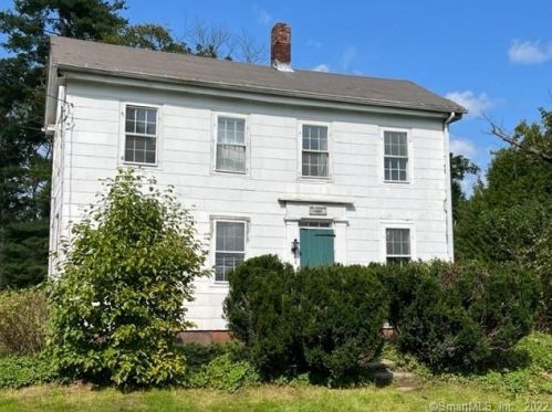
Cost estimate history
| Year | Tax | Assessment | Market |
|---|---|---|---|
| 2014 | $3,723 | $159,300 | N/A |
Market Activities
To date, we have no information about market activities in 2025
Apr 2024
Sold
Dec 2023
Sold
Oct 2023
Sold
Mar 2023
Sold
Nov 2022
Sold
299 Main St Fire Incident History
To date, we have no information about fire incidents in 2025
04 Aug 2005
Cooking fire, confined to container
Property Use —
1 or 2 family dwelling
Area of Origin —
Cooking area, kitchen
First Ignition —
Cooking materials, including edible materials
Heat Source —
Heat source: other
17 Apr 2003
Passenger vehicle fire
Property Use —
Highway or divided highway
Area of Origin —
Cooking area, kitchen
First Ignition —
Cooking materials, including edible materials
Heat Source —
Heat source: other
Main St Fire Incident History
To date, we have no information about fire incidents in 2025
22 Aug 2019
Passenger vehicle fire
Property Use —
Motor vehicle or boat sales, services, repair
Area of Origin —
Engine area, running gear, wheel area
First Ignition —
Electrical wire, cable insulation
Heat Source —
Arcing
24 Oct 2018
Passenger vehicle fire
Property Use —
Vehicle parking area
Area of Origin —
Operator/passenger area of transportation equip.
First Ignition —
Upholstered sofa, chair, vehicle seats
Heat Source —
Arcing
31 Mar 2018
Forest, woods or wildland fire
Property Use —
Graded and cared-for plots of land
Area of Origin —
Wildland, woods
First Ignition —
Heavy vegetation - not crop, including trees
Heat Source —
Arcing
12 May 2017
Outside equipment fire
Property Use —
Amusement center: indoor/outdoor
Area of Origin —
Assembly area without fixed seats - 100+ persons
First Ignition —
Light vegetation - not crop, including grass
Heat Source —
Radiated, conducted heat from operating equipment
299 Main St incidents registered in FEMA
(Federal Emergency Management Agency)
To date, we have no information about incidents registered in FEMA in 2025
14 Dec 2015
Unauthorized burning
Property Use —
Open land or field
17 Aug 2012
Chemical spill or leak
Property Use —
Highway or divided highway
20 Feb 2012
Unauthorized burning
Property Use —
1 or 2 family dwelling
Main St Incidents registered in FEMA
(Federal Emergency Management Agency)
To date, we have no information about incidents registered in FEMA in 2025
14 Dec 2015
Unauthorized burning
Property Use —
Open land or field
25 Nov 2015
Unauthorized burning
Property Use —
1 or 2 family dwelling
08 Sep 2015
Authorized controlled burning
Property Use —
Personal service, including barber & beauty shops
05 Sep 2015
Unauthorized burning
Property Use —
1 or 2 family dwelling
Properties Nearby
| Street Address | Residens/Landlords | |
|---|---|---|
84 Main St, Somers, CT 06071-1841 Multi-Family Home
|
Daniel J Allen, Martin P Callahan | |
155 Main St, Somers, CT 06071-1823 Multiple Occupancy
|
G Cormier, Isabella C Cormier |
Schools near property
| Name | Type | Grade | Distance |
|---|---|---|---|
| Elementary school | |||
| Somers Elementary School Ninth District Rd, Somers, CT 06071 860-749-3516 | Public | PK-5 | 1.17 |
| Middle school | |||
| Mabelle B. Avery Middle School Ninth District Rd, Somers, CT 06071 860-763-0723 | Public | 6-8 | 1.18 |
| High school | |||
| Somers High School 5 Vision Boulevard, Somers, CT 06071 860-749-2270 | Public | 9-12 | 1.16 |
