Purchase History
| Date | Event | Price | Source | Agents |
|---|---|---|---|---|
| 05/23/2007 | Sold | $210,000 | Public records | |
| 05/24/2005 | Sold | $167,000 | Public records | |
| 07/13/2004 | Sold | $17,500 | Public records |
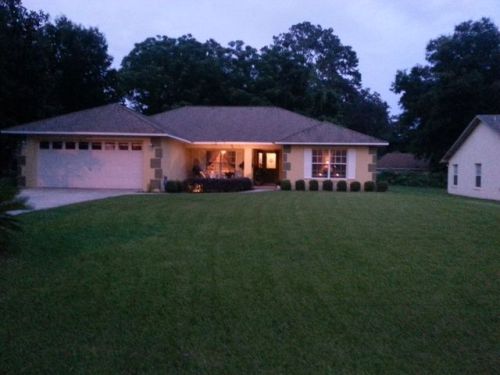
PURCHASE HISTORY 12433 60th Ave, Belleview FL
Cost estimate history
| Year | Tax | Assessment | Market |
|---|---|---|---|
| 2013 | $1,482 | $116,308 | $119,828 |
Market Activities
60th Ave Fire Incident History
To date, we have no information about fire incidents in 2025
28 Jul 2011
Grass fire
Property Use —
1 or 2 family dwelling
Area of Origin —
Outside area, other
First Ignition —
Light vegetation - not crop, including grass
Heat Source —
Arcing
12433 60 Ave incidents registered in FEMA
(Federal Emergency Management Agency)
To date, we have no information about incidents registered in FEMA in 2025
08 Nov 2009
Authorized controlled burning
Property Use —
1 or 2 family dwelling
60 Ave Incidents registered in FEMA
(Federal Emergency Management Agency)
To date, we have no information about incidents registered in FEMA in 2025
20 Jun 2012
Unauthorized burning
Property Use —
Outside or special property, other
02 Jun 2011
Unauthorized burning
Property Use —
1 or 2 family dwelling
10 Nov 2010
Authorized controlled burning
Property Use —
Graded and cared-for plots of land
08 Nov 2009
Authorized controlled burning
Property Use —
1 or 2 family dwelling
Properties Nearby
| Street Address | Residens/Landlords |
|---|