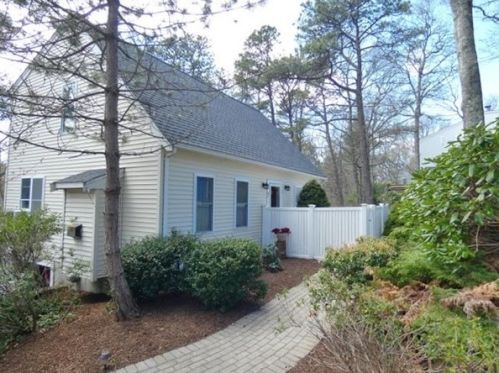
7 Santuit Pond Rd Mashpee, MA 02649 / 2422

Residence for Single Family

(UPDATED: 07/19/2025)
  • 2 Beds
  • 2 Baths
  • 0.3 acres
Sold Jun 2021
$480,000
Property Report

Information about property on 7 Santuit Pond Rd, Mashpee MA, 02649-2422. Find out owner contacts, building history, price, neighborhood at Homemetry Address Directory.

Property Details

The single-family Cape-cod style estate is situated at 7 Santuit Pond Road, Mashpee, Massachusetts.

Facts

  • Built in 1999
  • Lot size 0,3 acres
  • Construction Frame
  • Rooms 5
  • Bedrooms 2
  • Stories 2 story
  • Style Cape Cod
  • Structure type Cape cod
  • Heating & Cooling
  • Heat type Forced air unit
  • Exterior Home Features
  • Exterior material Vinyl
  • Exterior walls Siding (Alum/Vinyl)
  • Roof type Asphalt

Misc

  • Units 1

Listing info

  • Last sold Aug 2003 for $100

Features

  • A/C

Householders and Tenants for 7 Santuit Pond Rd, Mashpee MA

Possible residents contact details

Person Name Phone Number Additional Info
Barbara M Deloid Age: 99
508-364-****
Residential status:
Homeowner
Claire Miller Age: 82
863-494-****
Job:
Clerical/White Collar
Donald B Blakeman
Gary Dellaposta
508-477-****
Miles J Deloid Age: 60
508-539-****
Residential status:
Homeowner
Job:
Craftsman/Blue Collar
Tracy A Deloid Age: 59
508-539-****
Residential status:
Homeowner
Tracy A Muldrew Age: 59
Residential status:
Homeowner
Job:
Service Occupations
Warren Miller Age: 92
863-494-****

Purchase History

DateEventPriceSourceAgents
08/01/2000 Sold $168,900 Public records

Cost estimate history

YearTaxAssessmentMarket
2014 $2,421 $257,800 N/A

Where is 7 Santuit Pond Rd, Mashpee MA located on map?

Market Activities

To date, we have no information about market activities in 2025
Jun 2021 Sold
7 Santuit Pond Rd
Price history :
  • Single Family
  • 1,428 sqft
  • 2 beds
  • 2 baths
Apr 2021 Sold
7 Santuit Pond Rd
Price history :
  • Single Family
  • 1,428 sqft
  • 2 beds
  • 2 baths

View more

Santuit Pond Rd Fire Incident History

To date, we have no information about fire incidents in 2025
24 Aug 2013 Outside rubbish, trash or waste fire
Property Use —
1 or 2 family dwelling
Area of Origin —
Open area - outside; included are farmland, field
First Ignition —
Rubbish, trash, or waste
Heat Source —
Match
19 Mar 2010 Outside mailbox fire
Property Use —
Residential street, road or residential driveway
Area of Origin —
Railroad right of way: on or near
First Ignition —
Box, carton, bag, basket, barrel
Heat Source —
Cigarette lighter

Santuit Pond Rd Incidents registered in FEMA
(Federal Emergency Management Agency)

To date, we have no information about incidents registered in FEMA in 2025
15 Sep 2014 Unauthorized burning
Property Use —
1 or 2 family dwelling
25 Aug 2013 Gasoline or other flammable liquid spill
Property Use —
1 or 2 family dwelling
09 Jul 2011 Trash or rubbish fire, contained
Property Use —
1 or 2 family dwelling
29 Oct 2005 Arcing, shorted electrical equipment
Property Use —
Multifamily dwellings

View more

Properties Nearby

Street AddressResidens/Landlords
6 Santuit Pond Rd, Mashpee, MA 02649-2419
Single Family Residential
  • 3 beds
  • 1 bath
  • Lot: 0.3 acres
  • Built in 1971
Adam A Aronson, Melinda J Aronson
 

FAQ about the house at 7 Santuit Pond Rd, Mashpee, MA


NOTICE: You may not use SpamRoom or the information it provides to make decisions about employment, credit, housing or any other purpose that would require Fair Credit Reporting Act (FCRA) compliance. SpamRoom is not a Consumer Reporting Agency (CRA) as defined by the FCRA and does not provide consumer reports.