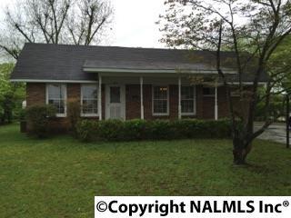
Cost estimate history
| Year | Tax | Assessment | Market |
|---|---|---|---|
| 2014 | $125 | N/A | N/A |
| 2013 | N/A | $6,280 | $62,600 |
Market Activities
Memorial Dr Fire Incident History
To date, we have no information about fire incidents in 2025
23 Oct 2019
Fire, other
Property Use —
Railroad right of way
Area of Origin —
Railroad right of way: on or near
First Ignition —
Railroad ties
Heat Source —
Heat source: other
04 Aug 2019
Brush, or brush and grass mixture fire
Property Use —
1 or 2 family dwelling
Area of Origin —
Outside area, other
First Ignition —
Light vegetation - not crop, including grass
Heat Source —
Cigarette lighter
04 Jun 2019
Natural vegetation fire, other
Property Use —
Vacant lot
Area of Origin —
Open area - outside; included are farmland, field
First Ignition —
Heavy vegetation - not crop, including trees
29 May 2019
Outside rubbish, trash or waste fire
Property Use —
Railroad right of way
Area of Origin —
Railroad right of way: on or near
First Ignition —
Railroad ties
Heat Source —
Flame/torch used for lighting
Properties Nearby
| Street Address | Residens/Landlords | |
|---|---|---|
112 Memorial Dr, Decatur, AL 35601-2264
|
John D Darsey, John D Dorsey | |
207 Memorial Dr, Decatur, AL 35601-2223 Single Family Residential
|
Jim A Clemons, Kenneth Reedus | |
210 Memorial Dr, Decatur, AL 35601-2224 Single Family Residential
|
M Brown, Shequita S Fields | |
222 Memorial Dr, Decatur, AL 35601-2224
|
Luelia Stewart, Nelson J Stewart | |
407 Memorial Dr, Decatur, AL 35601-2857 Single Family Residential
|
Fredrick Jaems Clay, Phillip C Cranfill | |
408 Memorial Dr, Decatur, AL 35601-2858 Single Family Residential
|
Anthony Lehman, Anthony Matthew | |
413 Memorial Dr, Decatur, AL 35601-2857 Single Family Residential
|
Jessie Burgess, Darrell Conarty | |
418 Memorial Dr, Decatur, AL 35601-1512 Single Family Residential
|
Rhonda Buford, Wanda Buford |

