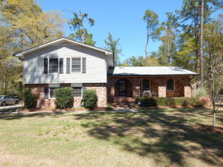

Cost estimate history
| Year | Tax | Assessment | Market |
|---|---|---|---|
| 2013 | N/A | N/A | $126,537 |
| 2011 | $1,786 | N/A | N/A |
Market Activities
Lundee Dr Fire Incident History
To date, we have no information about fire incidents in 2025
05 Nov 2012
Building fires
Property Use —
1 or 2 family dwelling
Area of Origin —
Open area - outside; included are farmland, field
First Ignition —
Light vegetation - not crop, including grass
Heat Source —
Hot ember or ash
08 Jan 2012
Building fires
Property Use —
1 or 2 family dwelling
Area of Origin —
Function area, other
First Ignition —
Rubbish, trash, or waste
Heat Source —
Cigarette
28 Apr 2004
Brush, or brush and grass mixture fire
Property Use —
1 or 2 family dwelling
Area of Origin —
Wildland, woods
First Ignition —
Heavy vegetation - not crop, including trees
Heat Source —
Hot or smoldering object, other
Lundee Dr Incidents registered in FEMA
(Federal Emergency Management Agency)
To date, we have no information about incidents registered in FEMA in 2025
27 Jun 2014
Overheated motor
Property Use —
1 or 2 family dwelling
31 Dec 2011
Authorized controlled burning
Property Use —
Open land or field
09 Mar 2004
Threat to burn
Property Use —
1 or 2 family dwelling
Properties Nearby
| Street Address | Residens/Landlords |
|---|