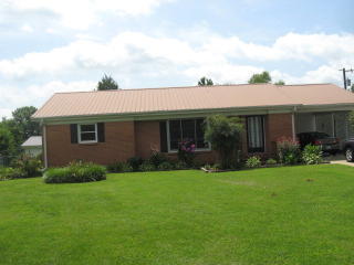
Purchase History
| Date | Event | Price | Source | Agents |
|---|---|---|---|---|
| 05/31/2005 | Sold | $13,350 | Public records | |
| 08/03/1998 | Sold | $66,500 | Public records |
Cost estimate history
| Year | Tax | Assessment | Market |
|---|---|---|---|
| 2013 | N/A | $20,920 | N/A |
| 2011 | N/A | N/A | $83,681 |
| 2010 | $549 | N/A | N/A |
Market Activities
Highway 79 Fire Incident History
To date, we have no information about fire incidents in 2025
23 Jun 2010
Cultivated grain or crop fire
Property Use —
Open land or field
Area of Origin —
Outside area, other
First Ignition —
Light vegetation - not crop, including grass
Heat Source —
Fireworks
27 Sep 2009
Building fires
Property Use —
Outbuilding or shed
Area of Origin —
Outside area, other
Heat Source —
Hot or smoldering object, other
24 Mar 2007
Brush, or brush and grass mixture fire
Property Use —
Open land or field
Area of Origin —
Open area - outside; included are farmland, field
Heat Source —
Heat from direct flame, convection currents
14 Jan 2006
Building fires
Property Use —
1 or 2 family dwelling
Area of Origin —
Bedroom - < 5 persons; included are jail or prison
First Ignition —
Magazine, newspaper, writing paper
Heat Source —
Candle
Hwy 79 Incidents registered in FEMA
(Federal Emergency Management Agency)
To date, we have no information about incidents registered in FEMA in 2025
14 Aug 2012
Authorized controlled burning
Property Use —
Open land or field
27 Sep 2008
Building fires
Property Use —
Outside material storage area
13 Aug 2007
Chemical spill or leak
Properties Nearby
| Street Address | Residens/Landlords | |
|---|---|---|
9990 Hwy79, Mc Kenzie, TN 38201-8890 Single Family Residential
|
Randy Clunk, Carol J Plunk | |
13015 Hwy79, Mc Kenzie, TN 38201-7814 Lot/Land
|

