Barnard Rd, New Rochelle NY street index
| Block | Buildings | Properties | Businesses | Residents |
|---|---|---|---|---|
| 1-199 | 1-199 | 44 | 20 | 187 |
| 200-256 | 200-256 | 11 | - | 13 |
Residents
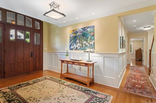
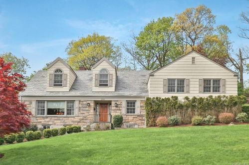
Residence for Single Family
- 5 beds
- 3.5 baths
- 3,400 sqft
- Built in 1947
Facts
Lot size: 0.36 acres

Who has lived here
| Resident | Phone Number | Additional info | |
|---|---|---|---|
|
Robert Allen
|
914-715-****
|
||
|
Stephen Rusch Age: 53
|
914-834-****
|
Residential status:
Homeowner
Job:
Professional/Technical
|
Who has lived here
| Resident | Phone Number | Additional info | |
|---|---|---|---|
|
Alal Forman
|
914-833-****
|
|
|
|
Alan N Forman Age: 64
|
914-833-****
|
||
|
Jocelyn Forman Age: 65
|
|
Residential status:
Homeowner
Job:
Sales Occupations
|
|
|
Robert L Osar
|
|
|
|
|
Johana Rosenberg
|
|
|
Who has lived here
| Resident | Phone Number | Additional info | |
|---|---|---|---|
|
Gian Luigi Buitoni
|
|
|
|
|
Maria D Cox Age: 63
|
914-325-****
|
Residential status:
Homeowner
Job:
Administrative Support Occupations, Including Clerical Occupations
Email:
|
|
|
Robert Cox
|
914-325-****
|
Residential status:
Homeowner
Job:
Administrative Support Occupations, Including Clerical Occupations
|
|
|
Brian R Mccauley
|
914-889-****
|
|
|
|
George C Sarris Age: 92
|
|
|
Residence for Single Family
- Lot: 0.38 acres
Facts
Lot size: 0.38 acres

Residence for Single Family
- Lot: 0.44 acres
Facts
Lot size: 0.44 acres

Who has lived here
| Resident | Phone Number | Additional info | |
|---|---|---|---|
|
Jean J Ferron
|
|
|
|
|
P Hepburn
|
|
|
Residence for Single Family
- Lot: 0.31 acres
Facts
Lot size: 0.31 acres

Residence for Single Family
- Lot: 0.41 acres
Facts
Lot size: 0.41 acres

Who has lived here
| Resident | Phone Number | Additional info | |
|---|---|---|---|
|
Roger Begelman
|
|
|
|
|
Fern N Goldstein Age: 67
|
914-633-****
|
|
|
|
Patrice R Guiol
|
|
|
Residence for Single Family
- Lot: 0.33 acres
Facts
Lot size: 0.33 acres

Residence for Single Family
- Lot: 0.32 acres
Facts
Lot size: 0.32 acres

Residence for Single Family
- Lot: 0.39 acres
Facts
Lot size: 0.39 acres

Residence for Single Family
- Lot: 7,841 sqft
Facts
Lot size: 7,841 sqft

Market Activities
To date, we have no information about market activities in 2025
Feb 2022
Sold
May 2021
Sold
May 2021
Sold
Fire Incident History
To date, we have no information about fire incidents in 2025
25 Jul 2012
Fires in structures other than in a building
Property Use —
Elementary school, including kindergarten
Area of Origin —
Heating room or area, water heater area
First Ignition —
Flammable liquid/gas - in/from engine or burner
Heat Source —
Heat from powered equipment, other
06 Jun 2006
Cooking fire, confined to container
Property Use —
Elementary school, including kindergarten
Area of Origin —
Common room, den, family room, living room, lounge
First Ignition —
Cooking materials, including edible materials
Heat Source —
Radiated, conducted heat from operating equipment
11 May 2006
Cooking fire, confined to container
Property Use —
1 or 2 family dwelling
Area of Origin —
Cooking area, kitchen
First Ignition —
Cooking materials, including edible materials
Heat Source —
Radiated, conducted heat from operating equipment
15 Mar 2006
Brush, or brush and grass mixture fire
Property Use —
Forest, timberland, woodland
Area of Origin —
Wildland, woods
First Ignition —
Cooking materials, including edible materials
Heat Source —
Radiated, conducted heat from operating equipment
Incidents registered in Federal Emergency Management Agency
To date, we have no information about incidents registered in FEMA in 2025
06 Nov 2015
Carbon monoxide incident
Property Use —
1 or 2 family dwelling
30 Jul 2015
Power line down
Property Use —
Residential street, road or residential driveway
03 Jul 2015
Gas leak (natural gas or LPG)
Property Use —
Residential street, road or residential driveway
15 Jun 2015
Electrical wiring/equipment problem, other
Property Use —
Elementary school, including kindergarten

